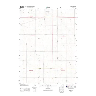
2013 Map of Raymer
USGS Topo · Published 2013About this map
Pawnee National Grassland dominates this section of the High Plains, where the grid of county roads meets the open prairie. The small town of Raymer sits along State Hwy 14, accompanied by the designation for New Raymer and a local Po. This 2013 survey illustrates the sparse, ranching-oriented landscape of the northern Colorado plains, marked by a systematic network of thoroughfares such as Co Road 129 and Co Road 131. The southern portion of the map records the jurisdictional boundary of Weld Co Morgan Co, showing the transition into the neighboring county. This area remains defined by its agricultural layout and the survival of small rural hubs that have historically served the surrounding grassland region.
Find a feature on this map
33 named features on this map. Tap any name to fly to it.
Don’t see what you’re looking for? This feature index may not catch every label — zoom into the map to look around manually.
Map Details
Editions of this 2013 Raymer Map
This is the sole edition of this map. No revisions or reprints were ever made.
Other maps of this area

1951 · Dead Horse Springs
USGS Topo · 1:24,000

1951 · Peace Valley School
USGS Topo · 1:24,000

1951 · Judson Hills
USGS Topo · 1:24,000

1954 · Sterling
USGS Topo · 1:250,000

1958 · Sterling
USGS Topo · 1:250,000
1977 · Raymer NW
USGS Topo · 1:24,000

1977 · Stoneham
USGS Topo · 1:24,000

1977 · Raymer NE
USGS Topo · 1:24,000
1978 · Buckingham
USGS Topo · 1:24,000

1978 · Stoneham NW
USGS Topo · 1:24,000