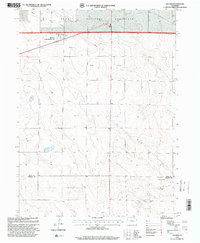
1997 Map of Raymer
USGS Topo · Published 2000About this map
Raymer (New Raymer PO) stands as the primary settlement in this high plains landscape of the late twentieth century, situated along a prominent east-west transportation corridor. The map reveals a rural economy transitioning between traditional agriculture and modern energy extraction, evidenced by the presence of numerous Oil Wells and a major Pipeline cutting across the northern sections. Educational and social life in the region is anchored by the Prairie School and the local Rodeo Ground, reflecting the community's cattle country roots. A large portion of the northern terrain is managed as part of the Pawnee National Grassland, where the land is marked by scattered infrastructure like a Water Tank and several Wells. Near the southern border, the line between Weld and Morgan Counties crosses the settlement of Townsend, providing a clear look at the jurisdictional boundaries of the Colorado plains.
Find a feature on this map
14 named features on this map. Tap any name to fly to it.
Don’t see what you’re looking for? This feature index may not catch every label — zoom into the map to look around manually.
Map Details
Editions of this 1997 Raymer Map
This is the sole edition of this map. No revisions or reprints were ever made.
Other maps of this area

1951 · Dead Horse Springs
USGS Topo · 1:24,000

1951 · Peace Valley School
USGS Topo · 1:24,000

1951 · Judson Hills
USGS Topo · 1:24,000

1954 · Sterling
USGS Topo · 1:250,000

1958 · Sterling
USGS Topo · 1:250,000
1977 · Raymer NW
USGS Topo · 1:24,000

1977 · Stoneham
USGS Topo · 1:24,000

1977 · Raymer NE
USGS Topo · 1:24,000
1978 · Buckingham
USGS Topo · 1:24,000

1978 · Stoneham NW
USGS Topo · 1:24,000