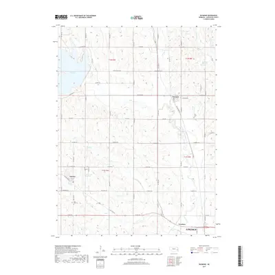
2017 Map of Raymond
USGS Topo · Published 2017About this map
Raymond and Malcolm anchor this agricultural landscape northwest of Lincoln, where the rolling terrain of Lancaster County is defined by the headwaters of Oak Creek. The presence of several local burial grounds, including Oak Creek Cem and Saint Pauls Cem, provides specific points of interest for those tracing family history in the township blocks of t12n r5e and t11n r6e. Water management is a central theme of the geography here, with the large expanse of Branched Oak Lake in the northwest and smaller catchments like Bradley North Reservoir and Moessner Reservoir dotting the drainages. The map reveals a transition from the developing northern outskirts of the state capital toward the more open, creek-carved prairies where Woodlawn sits near the confluence of Elk Cr and Oak Creek.
Find a feature on this map
31 named features on this map. Tap any name to fly to it.
Don’t see what you’re looking for? This feature index may not catch every label — zoom into the map to look around manually.
Map Details
Editions of this 2017 Raymond Map
This is the sole edition of this map. No revisions or reprints were ever made.
Other maps of this area

1897 · Lincoln
USGS Topo · 1:125,000

1899 · Wahoo
USGS Topo · 1:125,000

1955 · Fremont
USGS Topo · 1:250,000

1955 · Lincoln
USGS Topo · 1:250,000

1957 · Fremont
USGS Topo · 1:250,000

1957 · Lincoln
USGS Topo · 1:250,000

1958 · Fremont
USGS Topo · 1:250,000

1958 · Lincoln
USGS Topo · 1:250,000
1964 · Garland
USGS Topo · 1:24,000
1964 · Pleasant Dale
USGS Topo · 1:24,000