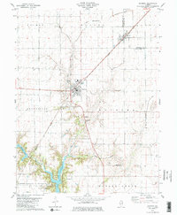
1979 Map of Raymond
USGS Topo · Published 1980About this map
Raymond and Harvel serve as the primary hubs of this central Illinois prairie landscape, positioned along the busy corridor of the Norfolk and Western railroad. The map documents a transition from the strictly gridded farmland of Pitman and King townships to the more varied topography surrounding the northern reaches of Lake Lou Yaeger. This reservoir dominates the southern portion of the sheet, providing a contrast to the agricultural patterns of the Montgomery County countryside.
Find a feature on this map
33 named features on this map. Tap any name to fly to it.
Don’t see what you’re looking for? This feature index may not catch every label — zoom into the map to look around manually.
Map Details
Editions of this 1979 Raymond Map
2 editions found
Other maps of this area

1915 · Mount Olive
USGS Topo · 1:62,500

1923 · Raymond
USGS Topo · 1:62,500

1925 · Raymond
USGS Topo · 1:62,500

1944 · Mount Olive
USGS Topo · 1:62,500

1946 · Nokomis
USGS Topo · 1:62,500

1947 · Hillsboro
USGS Topo · 1:62,500

1949 · Hillsboro
USGS Topo · 1:62,500

1949 · Nokomis
USGS Topo · 1:62,500

1958 · Decatur
USGS Topo · 1:250,000

1961 · Decatur
USGS Topo · 1:250,000