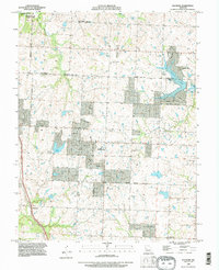
1990 Map of Raymore
USGS Topo · Published 1996About this map
Raymore stands as the central hub of this 1990 survey, showing the suburban expansion along the border of Jackson and Cass Counties. The map reveals a transition from traditional agricultural land toward residential development, notably around Lake Winnebago and the intricate shoreline of Raintree Lake. These man-made water features, along with Silver Lake and Johnston Lake, indicate a shift in the local landscape toward recreational and planned community use.
Find a feature on this map
26 named features on this map. Tap any name to fly to it.
Don’t see what you’re looking for? This feature index may not catch every label — zoom into the map to look around manually.
Map Details
Editions of this 1990 Raymore Map
This is the sole edition of this map. No revisions or reprints were ever made.
Other maps of this area

1887 · Harrisonville
USGS Topo · 1:125,000

1887 · Olathe
USGS Topo · 1:125,000

1892 · Harrisonville
USGS Topo · 1:125,000

1893 · Olathe
USGS Topo · 1:125,000

1894 · Harrisonville
USGS Topo · 1:125,000

1934 · Grandview
USGS Topo · 1:24,000

1934 · Lees Summit
USGS Topo · 1:24,000

1934 · Woods Chapel
USGS Topo · 1:24,000

1939 · Grandview
USGS Topo · 1:31,680

1939 · Lees Summit
USGS Topo · 1:31,680