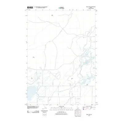
2010 Map of Rays Lake
USGS Topo · Published 2010About this map
Camas Creek meanders through this portion of Jefferson County, defining a landscape of complex water management and high-desert terrain. The eastern section is characterized by a network of seasonal water bodies and marshes, including Muskrat Pond, Two-way Pond, and Mallard Slough, all feeding into the namesake Rays Lake. This area reflects a reliance on intricate irrigation systems, evidenced by the Holly Canal, Jackett Canal, and Independent Ditch that crisscross the lowlands to support regional agriculture. Above the wetlands, distinctive geological formations like Table Butte, Clay Butte, and Bunker Hill rise from the plain. The map also traces the Camas Refuge Rd, suggesting the proximity of protected wildlife habitats in this corner of Idaho as it appeared during the early 21st century.
Find a feature on this map
27 named features on this map. Tap any name to fly to it.
Don’t see what you’re looking for? This feature index may not catch every label — zoom into the map to look around manually.
Map Details
Editions of this 2010 Rays Lake Map
This is the sole edition of this map. No revisions or reprints were ever made.
Other maps of this area

1955 · Dubois
USGS Topo · 1:250,000

1955 · Idaho Falls
USGS Topo · 1:250,000

1958 · Dubois
USGS Topo · 1:250,000

1958 · Idaho Falls
USGS Topo · 1:250,000

1964 · Terreton
USGS Topo · 1:24,000
1964 · Market Lake
USGS Topo · 1:24,000

1964 · Cedar Butte SW
USGS Topo · 1:24,000

1964 · Mud Lake SE
USGS Topo · 1:24,000
1964 · Hamer
USGS Topo · 1:24,000

1964 · Mud Lake NW
USGS Topo · 1:24,000