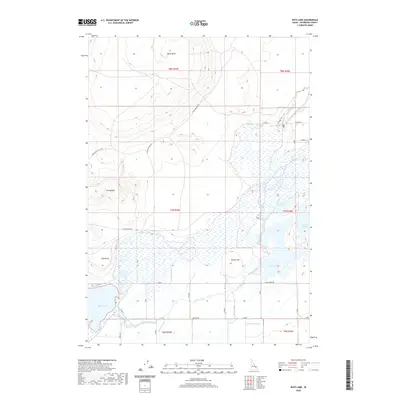
2020 Map of Rays Lake
USGS Topo · Published 2020About this map
Camas Creek meanders through this portion of Jefferson County, defining a landscape shaped by water management and volcanic terrain. In the southern reach, a complex network of man-made waterways including the Independent Ditch, Jackett Canal, and Holly Canal reflects the agricultural reliance on irrigation to sustain the high desert flats. These channels feed into and around Rays Lake and the eastern edge of Mud Lake, where the wetlands provide a stark contrast to the surrounding elevations. To the north, the topography rises toward distinct volcanic landmarks such as Table Butte and Bunker Hill. The transition between the wet lowlands and the higher plateaus is marked by the irregular erosional features known as The Breaks, while localized heights like Clay Butte stand over the marshy basin. This survey documents the intersection of natural hydrology and human-engineered water systems in a specialized Idaho environment.
Find a feature on this map
32 named features on this map. Tap any name to fly to it.
Don’t see what you’re looking for? This feature index may not catch every label — zoom into the map to look around manually.
Map Details
Editions of this 2020 Rays Lake Map
This is the sole edition of this map. No revisions or reprints were ever made.
Other maps of this area

1955 · Dubois
USGS Topo · 1:250,000

1955 · Idaho Falls
USGS Topo · 1:250,000

1958 · Dubois
USGS Topo · 1:250,000

1958 · Idaho Falls
USGS Topo · 1:250,000

1964 · Terreton
USGS Topo · 1:24,000
1964 · Market Lake
USGS Topo · 1:24,000

1964 · Cedar Butte SW
USGS Topo · 1:24,000

1964 · Mud Lake SE
USGS Topo · 1:24,000
1964 · Hamer
USGS Topo · 1:24,000

1964 · Mud Lake NW
USGS Topo · 1:24,000