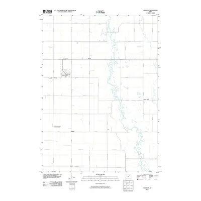
2010 Map of Readlyn
USGS Topo · Published 2010About this map
The Wapsipinicon River meanders through the heart of this Bremer County landscape, its complex channel creating a corridor of wetlands and natural drainage that defines the local geography. The town of Readlyn serves as the primary hub, where the Readlyn Post Office is centrally located amidst a grid of residential streets. This map is particularly valuable for genealogical research, documenting several denominational burial grounds including Saint Mathews Lutheran Cemetery, Saint Pauls Cemetery, and Zions Cemetery near the town center, along with the Emanuel Evangelical Lutheran Cemetery further south near Klinger. The rural area is organized by a precise network of county roads like Tahoe Ave and Viking Ave, which connect smaller named locales such as Wapsie, Key, and Grove Hill. This 2010 survey reflects a stable agricultural community where historical church and cemetery sites remain as prominent landmarks against the modern township grid.
Find a feature on this map
43 named features on this map. Tap any name to fly to it.
Don’t see what you’re looking for? This feature index may not catch every label — zoom into the map to look around manually.
Map Details
Editions of this 2010 Readlyn Map
This is the sole edition of this map. No revisions or reprints were ever made.
Other maps of this area

1954 · Waterloo
USGS Topo · 1:250,000

1955 · Waterloo
USGS Topo · 1:250,000

1963 · Denver
USGS Topo · 1:24,000

1963 · Waterloo North
USGS Topo · 1:24,000

1971 · Readlyn
USGS Topo · 1:24,000

1971 · Sumner
USGS Topo · 1:24,000

1971 · Sumner SW
USGS Topo · 1:24,000

1971 · Dunkerton
USGS Topo · 1:24,000

1971 · Fairbank
USGS Topo · 1:24,000

1971 · Tripoli
USGS Topo · 1:24,000