
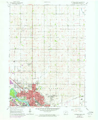
1963 Map of Waterloo North
USGS Topo · Published 1965About this map
The Cedar River and Black Hawk Cr converge in this mid-century portrait of Waterloo, reflecting a period of significant urban density and infrastructure development. The city’s core is tightly packed with educational and religious institutions, from East High School to Our Lady of Victory School. Industrial footprints are evident in the numerous sandpits and quarries along the riverbanks, while the presence of the Chicago Great Western and Rock Island railroads underscores the city's role as a regional transportation hub.
Find a feature on this map
56 named features on this map. Tap any name to fly to it.
Don’t see what you’re looking for? This feature index may not catch every label — zoom into the map to look around manually.
Map Details
Editions of this 1963 Waterloo North Map
2 editions found
Other maps of this area

1954 · Waterloo
USGS Topo · 1:250,000

1955 · Waterloo
USGS Topo · 1:250,000

1963 · Waverly
USGS Topo · 1:24,000

1963 · Denver
USGS Topo · 1:24,000

1963 · Hudson
USGS Topo · 1:24,000

1963 · Waterloo South
USGS Topo · 1:24,000

1963 · Cedar Falls
USGS Topo · 1:24,000

1971 · Readlyn
USGS Topo · 1:24,000

1971 · Gilbertville
USGS Topo · 1:24,000

1971 · Dunkerton
USGS Topo · 1:24,000