
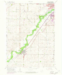
1963 Map of Hudson
USGS Topo · Published 1964About this map
Hudson anchor’s the southwestern corner of this mid-century survey, situated along the diagonal path of the Chicago Great Western railroad. The landscape is defined by the winding course of Black Hawk Creek, which creates a lush corridor through the agricultural lands of Black Hawk and Orange townships. The map documents the outskirts of Waterloo and Cedar Falls before the significant suburban expansion of the later 20th century, showing a pattern of section-line roads and dispersed farmsteads.
Find a feature on this map
26 named features on this map. Tap any name to fly to it.
Don’t see what you’re looking for? This feature index may not catch every label — zoom into the map to look around manually.
Map Details
Editions of this 1963 Hudson Map
2 editions found
Other maps of this area

1954 · Waterloo
USGS Topo · 1:250,000

1955 · Waterloo
USGS Topo · 1:250,000

1963 · Buckingham
USGS Topo · 1:24,000

1963 · Waterloo South
USGS Topo · 1:24,000

1963 · Eagle Center
USGS Topo · 1:24,000

1963 · Cedar Falls
USGS Topo · 1:24,000

1963 · Waterloo North
USGS Topo · 1:24,000

1971 · Zaneta
USGS Topo · 1:24,000

1971 · Reinbeck
USGS Topo · 1:24,000
1971 · New Hartford
USGS Topo · 1:24,000