
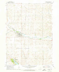
1971 Map of Reinbeck
USGS Topo · Published 1973About this map
Black Hawk Creek winds through the northern reaches of this rural landscape, carving a path through the intersection of Grundy, Black Hawk, and Tama counties. This 1971 field-checked survey reveals a region defined by its agricultural grid and the crucial rail corridors that sustained it. The Chicago and North Western line crosses the northeastern corner near Hicks, while the Chicago Rock Island and Pacific railroad bisects the southern townships. The town of Reinbeck serves as the primary hub, showing its established street grid and proximity to Mosquito Creek. Further south in Grant township, a small cluster of community life is anchored by Amity Ch and the neighboring Amity Cem. Several other family and community burial grounds, including Weiss Cem and Lincoln Cem, are scattered across the townships, providing vital markers for genealogical research in this corner of the Iowa prairie.
Find a feature on this map
26 named features on this map. Tap any name to fly to it.
Don’t see what you’re looking for? This feature index may not catch every label — zoom into the map to look around manually.
Map Details
Editions of this 1971 Reinbeck Map
This is the sole edition of this map. No revisions or reprints were ever made.
Other maps of this area

1954 · Waterloo
USGS Topo · 1:250,000

1955 · Waterloo
USGS Topo · 1:250,000

1963 · Buckingham
USGS Topo · 1:24,000

1963 · Hudson
USGS Topo · 1:24,000

1971 · Gladbrook NE
USGS Topo · 1:24,000

1971 · Zaneta
USGS Topo · 1:24,000

1971 · Dike
USGS Topo · 1:24,000

1971 · Lincoln
USGS Topo · 1:24,000

1971 · Traer
USGS Topo · 1:24,000
1971 · Gladbrook
USGS Topo · 1:24,000