
1971 Map of Lincoln
USGS Topo · Published 1973About this map
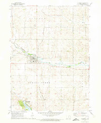
The town of Lincoln anchors the southern portion of this Iowa landscape, situated at the boundary of Lincoln and Grant townships. Just north of the Grundy Co Tama Co line, the settlement of Morrison sits along the Chicago Rock Island and Pacific railroad, which follows the path of Black Hawk Creek. This corridor is a hub of local activity, featuring Shearin Park and a Golf Course situated near the waterway's bends.
Find a feature on this map
20 named features on this map. Tap any name to fly to it.
Don’t see what you’re looking for? This feature index may not catch every label — zoom into the map to look around manually.
Map Details
Editions of this 1971 Lincoln Map
This is the sole edition of this map. No revisions or reprints were ever made.
Other maps of this area

1954 · Waterloo
USGS Topo · 1:250,000

1955 · Waterloo
USGS Topo · 1:250,000

1960 · Marshalltown
USGS Topo · 1:62,500

1960 · Conrad East
USGS Topo · 1:24,000

1971 · Gladbrook NE
USGS Topo · 1:24,000

1971 · Zaneta
USGS Topo · 1:24,000

1971 · Dike
USGS Topo · 1:24,000

1971 · Reinbeck
USGS Topo · 1:24,000
1971 · Gladbrook
USGS Topo · 1:24,000

1979 · Grundy Center
USGS Topo · 1:24,000