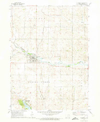
1971 Map of Gladbrook
USGS Topo · Published 1973About this map
The Chicago and North Western railroad bisects the landscape of northern Tama County, anchoring the town of Gladbrook as a local transportation hub. This 1971 survey highlights a region defined by its waterway network, where Wolf Creek and its tributaries like Devils Creek and Little Wolf Run carve through the agricultural terrain. The map provides significant genealogical value, documenting several rural burial grounds including Maple Hill Cem, Badger Hill Cem, and Gethman Cem. To the south, the recreational character of the area is evident at Union Grove State Park, which surrounds Union Grove Lake. The inclusion of fine red dashed lines to indicate fence and field lines, interpreted from 1967 aerial photography, offers a precise look at the land division and rural infrastructure during this period. Other notable landmarks include the local Fairground and a Quarry situated near the park boundary.
Find a feature on this map
24 named features on this map. Tap any name to fly to it.
Don’t see what you’re looking for? This feature index may not catch every label — zoom into the map to look around manually.
Map Details
Editions of this 1971 Gladbrook Map
2 editions found
Other maps of this area

1954 · Waterloo
USGS Topo · 1:250,000

1955 · Waterloo
USGS Topo · 1:250,000

1960 · Marshalltown
USGS Topo · 1:62,500

1960 · Le Grand
USGS Topo · 1:24,000

1960 · Conrad East
USGS Topo · 1:24,000

1971 · Gladbrook NE
USGS Topo · 1:24,000

1971 · Lincoln
USGS Topo · 1:24,000

1971 · Reinbeck
USGS Topo · 1:24,000

1971 · Garwin
USGS Topo · 1:24,000
1971 · Gladbrook SE
USGS Topo · 1:24,000