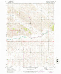
1971 Map of Gladbrook
USGS Topo · Published 1986About this map
Wolf Creek and its tributaries define the rolling agricultural landscape of northern Tama County during this 1970s era. The map provides a detailed view of rural land divisions within the townships of Grant, Buckingham, Crystal, and Perry, where scattered farmsteads are connected by a precise grid of country roads. Transportation history is etched into the terrain by the Chicago and Pacific and Rock Island rail corridor, which cuts diagonally across the northern sections near Twelvemile Creek. Local genealogy and community landmarks are anchored by several rural burial grounds, including Crystal Cem, Dinsdale Cem, and Bakers Grove Cem. Multiple Gaging Stations along the creeks suggest the importance of water management in this prairie watershed. Periodic revisions in the early 1980s highlight subtle changes in the built environment across this productive Iowa farmland.
Find a feature on this map
14 named features on this map. Tap any name to fly to it.
Don’t see what you’re looking for? This feature index may not catch every label — zoom into the map to look around manually.
Map Details
Editions of this 1971 Gladbrook Map
2 editions found
Other maps of this area

1954 · Waterloo
USGS Topo · 1:250,000

1955 · Waterloo
USGS Topo · 1:250,000

1960 · Marshalltown
USGS Topo · 1:62,500

1960 · Le Grand
USGS Topo · 1:24,000

1960 · Conrad East
USGS Topo · 1:24,000

1971 · Gladbrook NE
USGS Topo · 1:24,000

1971 · Lincoln
USGS Topo · 1:24,000

1971 · Reinbeck
USGS Topo · 1:24,000

1971 · Garwin
USGS Topo · 1:24,000
1971 · Gladbrook SE
USGS Topo · 1:24,000