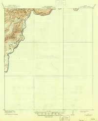
1918 Map of Reagan Canyon
USGS Topo · Published 1946About this map
The Rio Grande carves a winding path through this desolate stretch of Brewster County, defining the international boundary between the United States and Mexico. Surveyed in 1917, the map captures a landscape defined by extreme relief and isolated outposts of industry and habitation. Horn's Ranch sits on a small flat above the river, while further north, the presence of the Wax Factory suggests the early 20th-century harvesting of candelilla wax from native desert shrubs.
Find a feature on this map
9 named features on this map. Tap any name to fly to it.
Don’t see what you’re looking for? This feature index may not catch every label — zoom into the map to look around manually.
Map Details
Editions of this 1918 Reagan Canyon Map
4 editions found
Other maps of this area

1918 · Reagan Canyon
USGS Topo · 1:62,500

1918 · Dove Mountain
USGS Topo · 1:62,500

1918 · Bullis Gap
USGS Topo · 1:62,500

1918 · Indian Wells
USGS Topo · 1:62,500

1919 · Maravillas Canyon
USGS Topo · 1:62,500

1930 · Stillwell Creek
USGS Topo · 1:62,500

1959 · Emory Peak
USGS Topo · 1:250,000

1965 · Emory Peak
USGS Topo · 1:250,000
1971 · Stillwell Crossing
USGS Topo · 1:24,000
1983 · Las Vegas De Los Ladrones SW
USGS Topo · 1:24,000