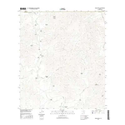
2016 Map of Reagan Wells
USGS Topo · Published 2016About this map
Reagan Wells sits at the heart of this landscape, where the ephemeral waters of the Dry Frio River have carved a complex network of canyons and ridges along the Real and Uvalde county line. The topography is defined by dozens of family-named drainages, such as Gaines Hollow, Fulghum Hollow, and Mine Hollow, suggesting a history of deep-seated local land tenure and early ranching efforts. Higher elevations are marked by the presence of Devils Backbone Mtn, while the floor of the river valley supports vital water sources like Lightning Bug Spring and the distinctive Squirrel Bend. The map provides a detailed view of the rural infrastructure, from the Flying J Ranch Airport to the Cummins Heard Cem, which offers a point of interest for those researching local family lineages. This area remains a study in the intersection of isolated Hill Country terrain and the essential transportation arteries of Ranch Road 1051 and FM 1051 N.
Find a feature on this map
48 named features on this map. Tap any name to fly to it.
Don’t see what you’re looking for? This feature index may not catch every label — zoom into the map to look around manually.
Map Details
Editions of this 2016 Reagan Wells Map
This is the sole edition of this map. No revisions or reprints were ever made.
Other maps of this area

1898 · Uvalde
USGS Topo · 1:125,000

1899 · Uvalde
USGS Topo · 1:125,000

1954 · San Antonio
USGS Topo · 1:250,000

1956 · Utopia
USGS Topo · 1:62,500

1957 · San Antonio
USGS Topo · 1:250,000

1957 · York Hollow
USGS Topo · 1:62,500

1960 · Concan
USGS Topo · 1:24,000

1960 · Magers Crossing
USGS Topo · 1:24,000
1969 · Rio Frio
USGS Topo · 1:24,000
1971 · Sycamore Mountain
USGS Topo · 1:24,000