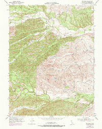
1952 Map of Red Bank
USGS Topo · Published 1970About this map
Red Bank Road and Lowrey Road wind through this corner of Tehama County, connecting the small settlement at Red Bank to the surrounding hills. The landscape is defined by a dense network of seasonal drainages, where Clover Creek and Red Bank Creek carve through the northern sections while Elder Creek flows prominently across the southern reaches. These watercourses are flanked by named topographical features like the wide expanse of Hungry Hollow and the upland plateau of Elk Flat.
Find a feature on this map
25 named features on this map. Tap any name to fly to it.
Don’t see what you’re looking for? This feature index may not catch every label — zoom into the map to look around manually.
Map Details
Editions of this 1952 Red Bank Map
2 editions found
Other maps of this area

1890 · Red Bluff
USGS Topo · 1:250,000

1894 · Red Bluff
USGS Topo · 1:250,000

1944 · Flournoy
USGS Topo · 1:62,500

1949 · Colyear Springs
USGS Topo · 1:62,500

1951 · West of Gerber
USGS Topo · 1:24,000

1951 · Red Bluff West
USGS Topo · 1:24,000

1952 · Blossom
USGS Topo · 1:24,000

1952 · Red Bank
USGS Topo · 1:24,000

1952 · Paskenta
USGS Topo · 1:62,500

1952 · Red Bank
USGS Topo · 1:62,500