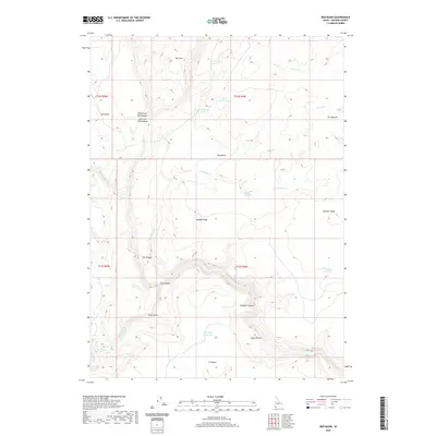
2020 Map of Red Basin
USGS Topo · Published 2020About this map
The Owyhee River carves a deep, winding path through the southwest corner of this Idaho landscape, defining the dramatic Owyhee Canyon. This high-desert terrain is characterized by complex drainages and named plateaus, where topographical landmarks like Lambert Table and Defeat Ridge rise above the surrounding basin. The survey captures a network of vital water sources in an arid environment, from the Big Bend Reservoir and Potter Reservoir to isolated points such as Rattlesnake Spring and Craig Spring.
Find a feature on this map
29 named features on this map. Tap any name to fly to it.
Don’t see what you’re looking for? This feature index may not catch every label — zoom into the map to look around manually.
Map Details
Editions of this 2020 Red Basin Map
This is the sole edition of this map. No revisions or reprints were ever made.
Other maps of this area

1955 · Jordan Valley
USGS Topo · 1:250,000

1957 · Jordan Valley
USGS Topo · 1:250,000

1958 · Jordan Valley
USGS Topo · 1:250,000

1973 · Red Basin
USGS Topo · 1:24,000
1973 · Piute Basin West
USGS Topo · 1:24,000

1973 · Smith Creek
USGS Topo · 1:24,000

1973 · Bedstead Ridge
USGS Topo · 1:24,000

1973 · Castro Table
USGS Topo · 1:24,000

1973 · Grassy Ridge
USGS Topo · 1:24,000

1973 · Spring Creek Basin
USGS Topo · 1:24,000