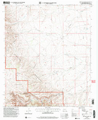
2001 Map of Red Bluff Draw
USGS Topo · Published 2003About this map
The Guadalupe Mountains dominate this landscape on the edge of the Lincoln National Forest, where water management defines the human presence in an arid environment. Named wells and springs are critical landmarks for navigation and ranching, including Four Wells, Tule Well, and Logan Spring. The map documents a rugged terrain carved by numerous drainages such as Dunnaway Draw, Last Chance Canyon, and Wagontire Draw, which cut through broad features like Bogle Flats and the Sotol Basin. Ranching heritage is evidenced by the H Bar Y Ranch, while more modern infrastructure is represented by the Sitting Bull Communication Facility. This survey, revised at the turn of the 21st century, captures the persistence of traditional land use alongside contemporary communication and resource extraction, including various gas wells and a Gravel Pit.
Find a feature on this map
36 named features on this map. Tap any name to fly to it.
Don’t see what you’re looking for? This feature index may not catch every label — zoom into the map to look around manually.
Map Details
Editions of this 2001 Red Bluff Draw Map
This is the sole edition of this map. No revisions or reprints were ever made.
Other maps of this area

1935 · El Paso Gap
USGS Topo · 1:62,500

1936 · El Paso Gap
USGS Topo · 1:48,000

1940 · El Paso Gap
USGS Topo · 1:62,500

1940 · Bandanna Point
USGS Topo · 1:62,500

1940 · Carlsbad Caverns West
USGS Topo · 1:62,500

1943 · Carlsbad Caverns West
USGS Topo · 1:62,500

1943 · Bandanna Point
USGS Topo · 1:62,500

1943 · Texas Hill
USGS Topo · 1:62,500

1945 · Texas Hill
USGS Topo · 1:62,500

1954 · Carlsbad
USGS Topo · 1:250,000