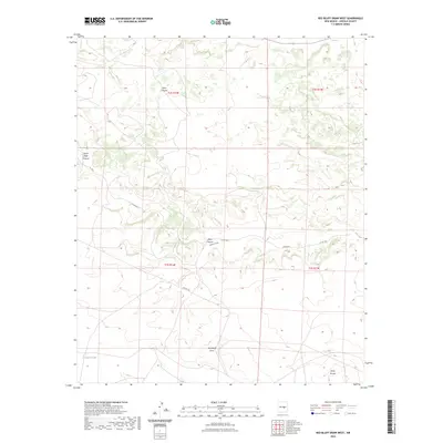
2023 Map of Red Bluff Draw West
USGS Topo · Published 2023About this map
Jesus Canyon and South Well Canyon define the northern drainage patterns of this Lincoln County landscape, where the high desert terrain transitions through a series of named mesas and draws. The map illustrates a contemporary view of land management and natural topography, anchored by the namesake Red Bluff Draw and the broad alluvial features of Gallo Arroyo to the southeast. Human activity is evidenced primarily by ranching and infrastructure features like Knollin Tank and the path of Co RD b015. The detailed contouring reveals the complex relief of Mesa Canyon and Bonita Canyon, providing a precise look at the geological character of the region. This modern survey integrates geographic data from several decades to show the current state of water features and local transit routes in this sparsely populated section of New Mexico.
Find a feature on this map
14 named features on this map. Tap any name to fly to it.
Don’t see what you’re looking for? This feature index may not catch every label — zoom into the map to look around manually.
Map Details
Editions of this 2023 Red Bluff Draw West Map
This is the sole edition of this map. No revisions or reprints were ever made.
Other maps of this area

1954 · Fort Sumner
USGS Topo · 1:250,000

1955 · Roswell
USGS Topo · 1:250,000

1958 · Fort Sumner
USGS Topo · 1:250,000

1958 · Roswell
USGS Topo · 1:250,000

1962 · Roswell
USGS Topo · 1:250,000

1973 · Chupadero Mountain
USGS Topo · 1:24,000

1980 · Corona
USGS Topo · 1:100,000

1981 · Gallo Spring Canyon
USGS Topo · 1:24,000
1981 · Pelon Hill
USGS Topo · 1:24,000
1981 · Red Bluff Draw East
USGS Topo · 1:24,000