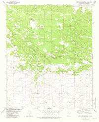
1981 Map of Red Bluff Draw West
USGS Topo · Published 1981About this map
Baker Place serves as a lone human marker in this arid stretch of Lincoln County, where the landscape is defined by the complex drainage systems of the high desert. The topographical detail reveals a rugged environment carved by Bonita Canyon, Jesus Canyon, and the sprawling Mesa Canyon. These deep incisions in the earth give way to Red Bluff Draw in the southern portion of the survey. The infrastructure of the early 1980s is limited but significant for the region, showing the necessity of water management through features like Baker Well and Knollin Tank. A network of pipelines and a Jeep Trail provide the primary means of traversal through this isolated terrain, while Gravel Pits in the north suggest localized industrial activity.
Find a feature on this map
12 named features on this map. Tap any name to fly to it.
Don’t see what you’re looking for? This feature index may not catch every label — zoom into the map to look around manually.
Map Details
Editions of this 1981 Red Bluff Draw West Map
This is the sole edition of this map. No revisions or reprints were ever made.
Other maps of this area

1954 · Fort Sumner
USGS Topo · 1:250,000

1955 · Roswell
USGS Topo · 1:250,000

1958 · Fort Sumner
USGS Topo · 1:250,000

1958 · Roswell
USGS Topo · 1:250,000

1962 · Roswell
USGS Topo · 1:250,000

1973 · Chupadero Mountain
USGS Topo · 1:24,000

1980 · Corona
USGS Topo · 1:100,000

1981 · Gallo Spring Canyon
USGS Topo · 1:24,000
1981 · Pelon Hill
USGS Topo · 1:24,000
1981 · Red Bluff Draw East
USGS Topo · 1:24,000