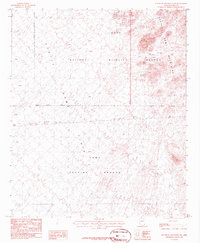
1986 Map of Red Bluff Mountain NW
USGS Topo · Published 1986About this map
The Kofa National Wildlife Refuge dominates the northern reaches of this mid-1980s landscape, protecting the stark desert terrain of the Castle Dome Mountains. To the south, the landscape transitions into the Yuma Proving Ground, where military activity and conservation interests meet along a shared Military Reservation Boundary. This intersection of federal land use is a defining characteristic of the region, illustrating the dual roles of the Arizona desert as both a natural sanctuary and a site for strategic operations.
Find a feature on this map
17 named features on this map. Tap any name to fly to it.
Don’t see what you’re looking for? This feature index may not catch every label — zoom into the map to look around manually.
Map Details
Editions of this 1986 Red Bluff Mountain NW Map
This is the sole edition of this map. No revisions or reprints were ever made.
Other maps of this area

1929 · Laguna
USGS Topo · 1:62,500

1939 · Red Hill
USGS Topo · 1:62,500

1942 · Yuma
USGS Topo · 1:250,000

1942 · Blythe
USGS Topo · 1:250,000

1943 · Laguna
USGS Topo · 1:62,500

1954 · El Centro
USGS Topo · 1:250,000

1954 · Salton Sea
USGS Topo · 1:250,000

1954 · Red Hill
USGS Topo · 1:62,500

1955 · Salton Sea
USGS Topo · 1:250,000

1955 · El Centro
USGS Topo · 1:250,000