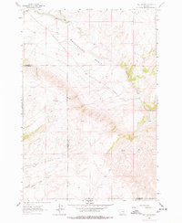
1961 Map of Red Canyon
USGS Topo · Published 1978About this map
Sweetwater Basin dominates this landscape along the border of Madison and Beaverhead counties, characterized by a complex network of drainages and seasonal water sources. The Ball Ranch represents the primary human footprint in this high-elevation terrain, situated near the confluence of Sweetwater Creek and its northern forks. The map reveals a land defined by water management and access, featuring remote Springs, Virginia Springs, and Crazy Springs Creek.
Find a feature on this map
15 named features on this map. Tap any name to fly to it.
Don’t see what you’re looking for? This feature index may not catch every label — zoom into the map to look around manually.
Map Details
Editions of this 1961 Red Canyon Map
2 editions found
Other maps of this area

1893 · Dillon
USGS Topo · 1:250,000

1955 · Dubois
USGS Topo · 1:250,000

1955 · Dillon
USGS Topo · 1:250,000

1957 · Dillon
USGS Topo · 1:250,000

1958 · Dubois
USGS Topo · 1:250,000

1958 · Dillon
USGS Topo · 1:250,000

1961 · Mine Gulch
USGS Topo · 1:24,000

1961 · Christensen Ranch
USGS Topo · 1:24,000

1961 · Red Canyon
USGS Topo · 1:24,000

1961 · Elk Gulch
USGS Topo · 1:24,000