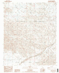
1986 Map of Red Canyon
USGS Topo · Published 1987About this map
Orocopia Mountains and the northern reaches of the Chocolate Mountains dominate this arid landscape in Riverside County. The terrain is defined by complex canyon systems and desert washes, most notably Red Canyon and the broad sweep of Salt Creek. The map records a transition from open public land to restricted territory, as evidenced by the Chocolate Mountain Aerial Gunnery Range and the nearby Naval Reservation Boundary in the southern sector.
Find a feature on this map
13 named features on this map. Tap any name to fly to it.
Don’t see what you’re looking for? This feature index may not catch every label — zoom into the map to look around manually.
Map Details
Editions of this 1986 Red Canyon Map
2 editions found
Other maps of this area

1940 · Frink
USGS Topo · 1:62,500

1940 · Cottonwood Spring
USGS Topo · 1:62,500

1940 · Canyon Spring
USGS Topo · 1:62,500

1940 · Durmid
USGS Topo · 1:62,500

1943 · Canyon Spring
USGS Topo · 1:62,500

1944 · Cottonwood Spring
USGS Topo · 1:62,500

1944 · Durmid
USGS Topo · 1:62,500

1944 · Frink
USGS Topo · 1:62,500

1954 · Salton Sea
USGS Topo · 1:250,000

1955 · Salton Sea
USGS Topo · 1:250,000