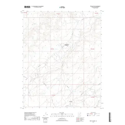
2018 Map of Red Clay Wash
USGS Topo · Published 2018About this map
Kinlichee sits at a geographic nexus in the high country of Apache County, where desert drainages carve distinct pathways through the landscape. This 2018 survey documents a remote portion of the Chinle Agency, defined by the seasonal flow of Red Clay Wash and Kinlichee Cr. The presence of the Woodspring Trading Post at the intersection of Navajo Svc Rte 27 and Woodsprings Rd highlights the area's continued role as a center for local commerce and navigation within the tribal landscape.
Find a feature on this map
28 named features on this map. Tap any name to fly to it.
Don’t see what you’re looking for? This feature index may not catch every label — zoom into the map to look around manually.
Map Details
Editions of this 2018 Red Clay Wash Map
This is the sole edition of this map. No revisions or reprints were ever made.
Other maps of this area

1886 · Fort Defiance
USGS Topo · 1:250,000

1892 · Fort Defiance
USGS Topo · 1:250,000

1954 · Gallup
USGS Topo · 1:250,000

1955 · Zith-Tusayan Butte 3 NW
USGS Topo · 1:24,000

1955 · Zith-Tusayan Butte 2 SE
USGS Topo · 1:24,000

1955 · Zith-Tusayan Butte 2 SW
USGS Topo · 1:24,000

1955 · Zith-Tusayan Butte 3 NE
USGS Topo · 1:24,000

1955 · Zith-Tusayan Butte 2 NW
USGS Topo · 1:24,000

1955 · Zith-Tusayan Butte 2 NE
USGS Topo · 1:24,000
1955 · Nazlini
USGS Topo · 1:62,500
Featured Places
- Chinle Agency, AZ
- Fort Defiance Agency
- Kinlichee, Fort Defiance Agency
- Wood Springs, Chinle Agency
- Apache County, AZ