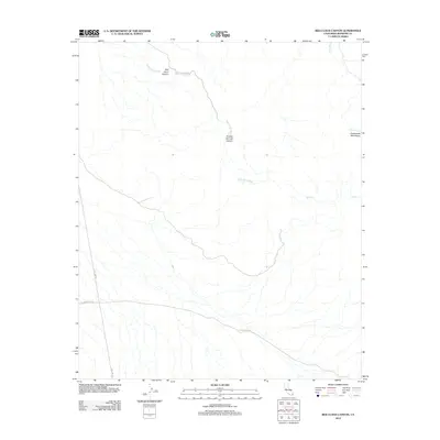
2012 Map of Red Cloud Canyon
USGS Topo · Published 2012About this map
The Chuckwalla Mountains define the arid landscape of this Riverside County region, where intricate drainage systems like Red Cloud Wash and Irish Wash carve through the terrain. Evidence of the area's mining history and early transit remains visible through the alignment of Red Cloud Mine Rd and The Bradshaw Trl, a historic overland route through the California desert. The map captures the intersection of natural features like Red Cloud Canyon and Crystal Springs Canyon with modern utility corridors such as Gas Line Rd. Smaller ephemeral watercourses like Ship Cr further illustrate the watershed patterns characteristic of this high-desert environment in the early twenty-first century.
Find a feature on this map
9 named features on this map. Tap any name to fly to it.
Don’t see what you’re looking for? This feature index may not catch every label — zoom into the map to look around manually.
Map Details
Editions of this 2012 Red Cloud Canyon Map
This is the sole edition of this map. No revisions or reprints were ever made.
Other maps of this area

1940 · Frink
USGS Topo · 1:62,500

1940 · Iris Pass
USGS Topo · 1:62,500

1940 · Canyon Spring
USGS Topo · 1:62,500

1943 · Canyon Spring
USGS Topo · 1:62,500

1944 · Chuckwalla Mountains
USGS Topo · 1:62,500

1944 · Frink
USGS Topo · 1:62,500

1945 · Iris Pass
USGS Topo · 1:62,500

1954 · Salton Sea
USGS Topo · 1:250,000

1955 · Salton Sea
USGS Topo · 1:250,000
1956 · Frink
USGS Topo · 1:62,500