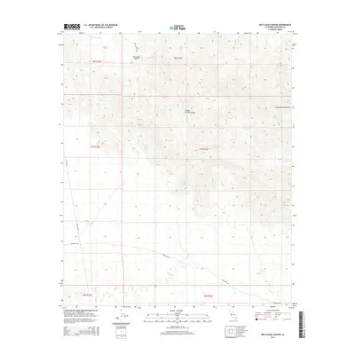
2015 Map of Red Cloud Canyon
USGS Topo · Published 2015About this map
Chuckwalla Mountains terrain dominates this Riverside County landscape, where deep desert washes and historical transit routes intersect. The mapping of Bradshaw Trl across the southern portion of the sheet marks the path of the famous 19th-century gold rush trail that once connected the Colorado River to the coast. In the north, the rugged topography of Red Cloud Canyon and Crystal Springs Canyon is accessed by the Red Cloud Mine Rd, reflecting the area's history of mineral exploration. Seasonal drainage patterns are clearly defined by Red Cloud Wash, Irish Wash, and Ship Cr, while modern infrastructure is represented by the north-south alignment of Gas Line Rd. This survey provides a precise look at the transition between high ridges and the desert floor in this remote interior region.
Find a feature on this map
15 named features on this map. Tap any name to fly to it.
Don’t see what you’re looking for? This feature index may not catch every label — zoom into the map to look around manually.
Map Details
Editions of this 2015 Red Cloud Canyon Map
This is the sole edition of this map. No revisions or reprints were ever made.
Other maps of this area

1940 · Frink
USGS Topo · 1:62,500

1940 · Iris Pass
USGS Topo · 1:62,500

1940 · Canyon Spring
USGS Topo · 1:62,500

1943 · Canyon Spring
USGS Topo · 1:62,500

1944 · Chuckwalla Mountains
USGS Topo · 1:62,500

1944 · Frink
USGS Topo · 1:62,500

1945 · Iris Pass
USGS Topo · 1:62,500

1954 · Salton Sea
USGS Topo · 1:250,000

1955 · Salton Sea
USGS Topo · 1:250,000
1956 · Frink
USGS Topo · 1:62,500