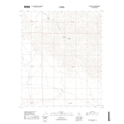
2018 Map of Red Cloud Canyon
USGS Topo · Published 2018About this map
The Chuckwalla Mountains dominate this 2018 survey, defining a landscape marked by deep drainage systems and arid desert corridors. Central to the area is Red Cloud Canyon, which is fed by Red Cloud Wash as it cuts through the high ground. The map details a network of desert routes that reflect the historical industrial and transit needs of this part of Riverside County, including the aptly named Red Cloud Mine Rd and the long-distance Bradshaw Rd traversing the southern portion of the sheet. Modern infrastructure is represented by the Gas Line Rd, which skirts the western edge of the mountains. Other significant topographical features include Crystal Springs Canyon and the seasonal watercourses of Iris Wash and Ship Cr, illustrating how water has shaped the terrain of this desert interior.
Find a feature on this map
15 named features on this map. Tap any name to fly to it.
Don’t see what you’re looking for? This feature index may not catch every label — zoom into the map to look around manually.
Map Details
Editions of this 2018 Red Cloud Canyon Map
This is the sole edition of this map. No revisions or reprints were ever made.
Other maps of this area

1940 · Frink
USGS Topo · 1:62,500

1940 · Iris Pass
USGS Topo · 1:62,500

1940 · Canyon Spring
USGS Topo · 1:62,500

1943 · Canyon Spring
USGS Topo · 1:62,500

1944 · Chuckwalla Mountains
USGS Topo · 1:62,500

1944 · Frink
USGS Topo · 1:62,500

1945 · Iris Pass
USGS Topo · 1:62,500

1954 · Salton Sea
USGS Topo · 1:250,000

1955 · Salton Sea
USGS Topo · 1:250,000
1956 · Frink
USGS Topo · 1:62,500