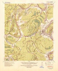
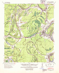
1939 Map of Red Gum
USGS Topo · Published 1941About this map
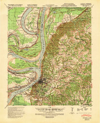
Ferriday serves as a central hub on this Mississippi River delta landscape, where the Vicksburg New Orleans and Missouri Pacific railroads converge. The terrain is defined by the complex hydrology of the Tensas River and Cocodrie Bayou, characterized by numerous oxbow lakes like Turtle Lake and Cocodrie Lake. Numerous landings along the riverbanks, including Dunbarton Ldg and Moorland Ldg, reflect a persistent reliance on water-borne commerce and transport in this fertile alluvial plain.
Find a feature on this map
82 named features on this map. Tap any name to fly to it.
Don’t see what you’re looking for? This feature index may not catch every label — zoom into the map to look around manually.
Map Details
Editions of this 1939 Red Gum Map
2 editions found
Other maps of this area

1909 · Sycamore Landing
USGS Topo · 1:24,000
1909 · Vidalia
USGS Topo · 1:24,000

1921 · Natchez
USGS Topo · 1:48,000
1922 · Natchez
USGS Topo · 1:62,500

1935 · Tooleys
USGS Topo · 1:62,500
1939 · Natchez
USGS Topo · 1:62,500
1939 · Kingston
USGS Topo · 1:62,500

1939 · Deer Park
USGS Topo · 1:62,500

1939 · Locust Ridge
USGS Topo · 1:62,500

1941 · Manifest
USGS Topo · 1:62,500