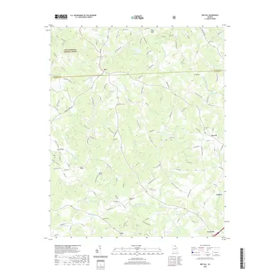
2020 Map of Red Hill
USGS Topo · Published 2020About this map
The Middle Fork Broad River and North Fork Broad River converge in this corner of Northeast Georgia, defining a landscape of creek-fed hollows and family homesteads. The Chattahoochee National Forest borders the northwestern edge, while the rest of the terrain is marked by small settlements like Mize, Red Hill, and Vandiver. This 2020 update highlights the enduring rural character of the region, where numerous family cemeteries such as Stowe Cem, Moss Cem, and Culpepper Cem are preserved among the winding county roads. Modern infrastructure is represented by spans like the Silver Shoals Bridge and McFarlin Bridge, which cross the river forks that have historically shaped local travel and property lines between Stephens and Franklin counties. Local water features like Teasley Lake and Pruitt Lake remain central landmarks in this predominantly agricultural area.
Find a feature on this map
139 named features on this map. Tap any name to fly to it.
Don’t see what you’re looking for? This feature index may not catch every label — zoom into the map to look around manually.
Map Details
Editions of this 2020 Red Hill Map
This is the sole edition of this map. No revisions or reprints were ever made.
Other maps of this area

1886 · Walhalla
USGS Topo · 1:125,000

1891 · Carnesville
USGS Topo · 1:125,000

1892 · Walhalla
USGS Topo · 1:125,000

1896 · Walhalla
USGS Topo · 1:125,000

1954 · Greenville
USGS Topo · 1:250,000

1958 · Greenville
USGS Topo · 1:250,000

1959 · Carnesville
USGS Topo · 1:24,000

1960 · Martin
USGS Topo · 1:24,000
1963 · Avalon
USGS Topo · 1:24,000
1964 · Ayersville
USGS Topo · 1:24,000