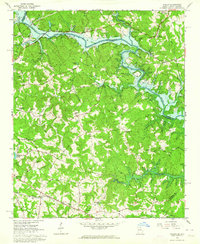
1963 Map of Avalon
USGS Topo · Published 1964About this map
Hartwell Reservoir dominates the landscape along the South Carolina and Georgia border, its rising waters reshaping the confluence of the Tugaloo River and Chauga River. The survey captures this transitional era for the region, where older riverfront landmarks like Mullins Ford and local crossings meet the expanding shoreline of the reservoir. To the south, the settlement of Avalon is situated along the Southern railroad line, serving as a hub for a rural landscape dotted with numerous country churches and schools. Local community life is evidenced by Tugaloo Ch, St Marks Ch, and the Eastanollee Sch. This detailed topography traces the complex network of creeks, including Little Eastanollee Creek and Gum Log Creek, that define the terrain as it rises toward the Chattahoochee National Forest to the northwest.
Find a feature on this map
72 named features on this map. Tap any name to fly to it.
Don’t see what you’re looking for? This feature index may not catch every label — zoom into the map to look around manually.
Map Details
Editions of this 1963 Avalon Map
Other maps of this area

1886 · Walhalla
USGS Topo · 1:125,000

1891 · Carnesville
USGS Topo · 1:125,000

1892 · Walhalla
USGS Topo · 1:125,000

1896 · Walhalla
USGS Topo · 1:125,000

1954 · Greenville
USGS Topo · 1:250,000

1957 · Tugaloo Lake
USGS Topo · 1:24,000

1958 · Greenville
USGS Topo · 1:250,000

1959 · Lavonia
USGS Topo · 1:24,000

1960 · Martin
USGS Topo · 1:24,000
1963 · Westminster
USGS Topo · 1:24,000