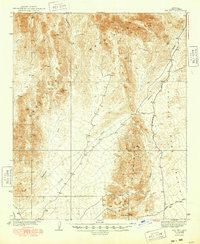
1939 Map of Red Hill
USGS Topo · Published 1948About this map
Annie Mine and the Los Angeles site anchor the desert activity in this 1930s survey of the Arizona wilderness. The landscape is defined by the massive drainage systems of Yuma Wash and Indian Wash, which cut through the arid terrain between the Trigo Mountains and the Middle Mountains. This era of documentation highlights the reliance on specialized routes such as the Mine Road and the established path toward Quartzsite. High points like Trip Mtn and Red Hill provide prominent landmarks overlooking the Castle Dome Plains, capturing the remote industrial and geological character of Yuma County before later development altered the region's accessibility.
Find a feature on this map
16 named features on this map. Tap any name to fly to it.
Don’t see what you’re looking for? This feature index may not catch every label — zoom into the map to look around manually.
Map Details
Editions of this 1939 Red Hill Map
3 editions found
Other maps of this area

1903 · Yuma
USGS Topo · 1:125,000

1905 · Yuma
USGS Topo · 1:125,000

1929 · Laguna
USGS Topo · 1:62,500

1934 · Trigo Peaks
USGS Topo · 1:48,000

1939 · Red Hill
USGS Topo · 1:62,500

1939 · Trigo Peaks
USGS Topo · 1:62,500

1942 · Yuma
USGS Topo · 1:250,000

1942 · Blythe
USGS Topo · 1:250,000

1943 · Laguna
USGS Topo · 1:62,500

1945 · Picacho Peak
USGS Topo · 1:62,500