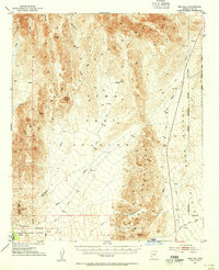
1954 Map of Red Hill
USGS Topo · Published 1955This historical map portrays the area of Red Hill in 1954, primarily covering La Paz County as well as portions of California. Featuring a scale of 1:62500, this map provides a highly detailed snapshot of the terrain, roads, buildings, counties, and historical landmarks in the Red Hill region at the time. Published in 1955, it is one of 3 known editions of this map due to revisions or reprints.
Find a feature on this map
18 named features on this map. Tap any name to fly to it.
Don’t see what you’re looking for? This feature index may not catch every label — zoom into the map to look around manually.
Map Details
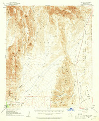
Editions of this 1954 Red Hill Map
3 editions found
Historical Maps of Yuma County Through Time
77 maps found

1930 Linskey
La Paz County, AZ

1933 Dome Rock Mts
La Paz County, AZ

1934 Trigo Peaks
La Paz County, AZ

1939 Red Hill
La Paz County, AZ

1939 Trigo Peaks
La Paz County, AZ

1940 Dome Rock Mts
La Paz County, AZ

1952 Mule Wash
La Paz County, AZ

1954 Red Hill
La Paz County, AZ

1954 Trigo Peaks
La Paz County, AZ

1955 La Paz Mtn
La Paz County, AZ

1955 Moon Mtn
La Paz County, AZ

1959 Black Peak
La Paz County, AZ

1959 La Paz Mtn
La Paz County, AZ

1961 Gladden
La Paz County, AZ

1961 Hope
La Paz County, AZ

1961 Lone Mountain
La Paz County, AZ

1964 Mule Wash
La Paz County, AZ

1965 Cibola SE
La Paz County, AZ

1965 Hidden Valley
La Paz County, AZ

1966 Alamo Dam
La Paz County, AZ

1966 Swansea
La Paz County, AZ

1967 E.C.P. Peak
La Paz County, AZ

1967 Smith Peak NW
La Paz County, AZ

1970 Parker SE
La Paz County, AZ

1971 Cunningham Mtn
La Paz County, AZ

1971 Dome Rock Mts SW
La Paz County, AZ

1971 Middle Camp Mtn.
La Paz County, AZ

1971 Moon Mtn NE
La Paz County, AZ

1971 Moon Mtn SE
La Paz County, AZ

1986 Middle Mountains North
La Paz County, AZ

1986 Mohave Peak
La Paz County, AZ

1986 North Trigo Peaks
La Paz County, AZ

1986 Red Hill
La Paz County, AZ

1986 Red Hill NE
La Paz County, AZ

1986 Red Hill SW
La Paz County, AZ

1986 Trigo Mts
La Paz County, AZ

1986 Trigo Pass
La Paz County, AZ

1986 Tweed Mine
La Paz County, AZ

1989 Socorro Peak
La Paz County, AZ

1989 Webber Canyon
La Paz County, AZ

1990 Alamo Dam
La Paz County, AZ

1990 Alamo Dam SE
La Paz County, AZ

1990 Bear Hills
La Paz County, AZ

1990 Black Peak
La Paz County, AZ

1990 Bobs Well
La Paz County, AZ

1990 Bouse Hills East
La Paz County, AZ

1990 Bouse Hills West
La Paz County, AZ

1990 Bouse NW
La Paz County, AZ

1990 Bouse SW
La Paz County, AZ

1990 Butler Pass
La Paz County, AZ

1990 Butler Well
La Paz County, AZ

1990 Cholla Tank
La Paz County, AZ

1990 Coyote Peak
La Paz County, AZ

1990 Crystal Hill
La Paz County, AZ

1990 Cunningham Pass
La Paz County, AZ

1990 Eagletail Mountains West
La Paz County, AZ

1990 East of Utting
La Paz County, AZ

1990 Harcuvar
La Paz County, AZ

1990 Harcuvar Peak
La Paz County, AZ

1990 Harrisburg Valley
La Paz County, AZ

1990 Hope
La Paz County, AZ

1990 Hope SE
La Paz County, AZ

1990 Hope SW
La Paz County, AZ

1990 Ibex Peak
La Paz County, AZ

1990 Little Horn Mountains NE
La Paz County, AZ

1990 Lone Mountain
La Paz County, AZ

1990 New Water Mountains
La Paz County, AZ

1990 New Water Well
La Paz County, AZ

1990 Osborne Well
La Paz County, AZ

1990 Owl Head
La Paz County, AZ

1990 Planet
La Paz County, AZ

1990 Plomosa Pass
La Paz County, AZ

1990 Powerline Well
La Paz County, AZ

1990 Reid Valley
La Paz County, AZ

1990 Socorro Mine
La Paz County, AZ

1990 South of Quartzsite
La Paz County, AZ

1990 Swansea
La Paz County, AZ