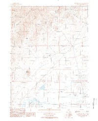
1988 Map of Red House Flat West
USGS Topo · Published 1989About this map
The Humboldt River and its accompanying wetlands define the southern landscape of this northern Nevada corridor, where the small settlement of Comus sits along the riverbank. This late 1980s provisional survey illustrates the stark transition from the alluvial plain of Red House Flat to the high elevations of the Osgood Mountains in the northwest. Water management and mining interests are central to the area's development, evidenced by the Hammond Ditch and several resource extraction sites including the Blue Bell Mine and various prospects scattered through Hogshead Canyon and Twin Canyon. The presence of Alkali Flats and remote watering points like Garden Spring and Dog Spring highlight the arid environment, while a prominent Trans Line and several 4WD tracks crisscrossing the desert floor indicate the region's importance for utility infrastructure and industrial access.
Find a feature on this map
23 named features on this map. Tap any name to fly to it.
Don’t see what you’re looking for? This feature index may not catch every label — zoom into the map to look around manually.
Map Details
Editions of this 1988 Red House Flat West Map
This is the sole edition of this map. No revisions or reprints were ever made.
Other maps of this area

1882 · Paradise
USGS Topo · 1:250,000

1893 · Paradise
USGS Topo · 1:250,000

1932 · Sonoma Range
USGS Topo · 1:250,000

1939 · Sonoma Range
USGS Topo · 1:250,000

1945 · Osgood Mountains
USGS Topo · 1:62,500

1947 · Osgood Mountains
USGS Topo · 1:62,500

1955 · McDermitt
USGS Topo · 1:250,000

1955 · Winnemucca
USGS Topo · 1:250,000

1958 · Winnemucca
USGS Topo · 1:250,000

1959 · McDermitt
USGS Topo · 1:250,000