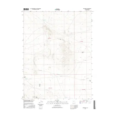
2017 Map of Red Knolls
USGS Topo · Published 2017About this map
Red Knolls rises as a prominent landmark above the surrounding desert terrain of Whirlwind Valley in this Millard County landscape. The area is defined by a complex network of dry watercourses, including Tin Well Wash, Soap Wash, and Swasey Wash, which signal the movement of seasonal water across the arid basin. Human presence is marked by infrastructure adapted to this environment, such as Swasey Reservoir Number 4 and the Highway Reservoir. These water management features, along with Soap Wash Reservoir and Swasey Wash Reservoir, indicate the importance of livestock and resource management in this part of Utah. The western edge of the valley is constrained by the elevation of Long Ridge, while navigation through the terrain relies on primitive routes like Death Canyon Rd and the historical corridor of Old 6 & 50.
Find a feature on this map
17 named features on this map. Tap any name to fly to it.
Don’t see what you’re looking for? This feature index may not catch every label — zoom into the map to look around manually.
Map Details
Editions of this 2017 Red Knolls Map
This is the sole edition of this map. No revisions or reprints were ever made.
Other maps of this area

1885 · Sevier Desert
USGS Topo · 1:250,000

1908 · Fish Springs
USGS Topo · 1:250,000

1910 · Fish Springs
USGS Topo · 1:250,000

1953 · Delta
USGS Topo · 1:250,000

1958 · Delta
USGS Topo · 1:250,000

1962 · Delta
USGS Topo · 1:250,000

1971 · Clay Knoll
USGS Topo · 1:24,000

1971 · Rocky Knoll
USGS Topo · 1:24,000
1971 · Smelter Knolls West
USGS Topo · 1:24,000

1972 · Whirlwind Valley SW
USGS Topo · 1:24,000