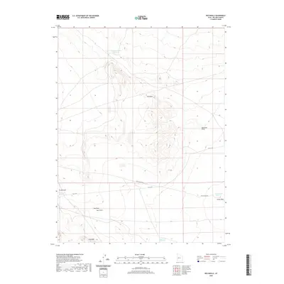
2020 Map of Red Knolls
USGS Topo · Published 2020About this map
Red Knolls and the surrounding high desert of Millard County are defined by a complex network of ephemeral drainage and remote water management. In this arid basin, land use is centered on a series of catchments including Swasey Reservoir Number 4, Highway Reservoir, and Soap Wash Reservoir, which support livestock or local transit across the scrubland. The terrain is marked by significant topographical features such as Whirlwind Valley and the prominent Long Ridge to the south. Transport through this isolated landscape follows the historical corridor of Old 6 & 50, while secondary routes like Death Canyon Rd provide access to the deep washes and hollows. This 2020 survey illustrates how modern mapping continues to track the vital water resources and rugged physical geography of the Great Basin.
Find a feature on this map
13 named features on this map. Tap any name to fly to it.
Don’t see what you’re looking for? This feature index may not catch every label — zoom into the map to look around manually.
Map Details
Editions of this 2020 Red Knolls Map
This is the sole edition of this map. No revisions or reprints were ever made.
Other maps of this area

1885 · Sevier Desert
USGS Topo · 1:250,000

1908 · Fish Springs
USGS Topo · 1:250,000

1910 · Fish Springs
USGS Topo · 1:250,000

1953 · Delta
USGS Topo · 1:250,000

1958 · Delta
USGS Topo · 1:250,000

1962 · Delta
USGS Topo · 1:250,000

1971 · Clay Knoll
USGS Topo · 1:24,000

1971 · Rocky Knoll
USGS Topo · 1:24,000
1971 · Smelter Knolls West
USGS Topo · 1:24,000

1972 · Whirlwind Valley SW
USGS Topo · 1:24,000