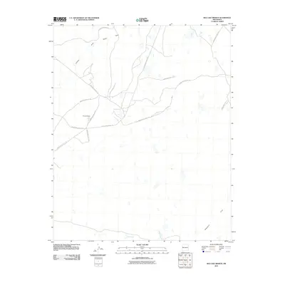
2010 Map of Red Lake Mission
USGS Topo · Published 2010About this map
Red Lake Mission serves as the focal point for this high-desert landscape in the Eastern Navajo Agency. The area is defined by a sparse network of Bureau of Indian Affairs transportation corridors, including Indian Service Route 131 and Indian Service Route 125, which navigate the subtle drainage patterns of the high plateau. The topography is characterized by seasonal water features and broad lowlands such as Bull Lake, Laguna Larga, and the wide expanse of Penasco Flat.
Find a feature on this map
17 named features on this map. Tap any name to fly to it.
Don’t see what you’re looking for? This feature index may not catch every label — zoom into the map to look around manually.
Map Details
Editions of this 2010 Red Lake Mission Map
This is the sole edition of this map. No revisions or reprints were ever made.
Other maps of this area

1954 · Saint Johns
USGS Topo · 1:250,000

1957 · Saint Johns
USGS Topo · 1:250,000

1958 · Saint Johns
USGS Topo · 1:250,000

1962 · Saint Johns
USGS Topo · 1:250,000

1967 · Red Lake Mission
USGS Topo · 1:24,000

1967 · Chimney Hill
USGS Topo · 1:24,000
1967 · Goat Hill
USGS Topo · 1:24,000

1967 · Cerro Alto
USGS Topo · 1:24,000
1967 · Cerro Pomo
USGS Topo · 1:24,000
1967 · Nicoll Lake
USGS Topo · 1:24,000