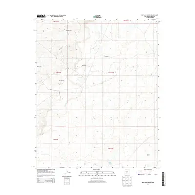
2013 Map of Red Lake Mission
USGS Topo · Published 2013About this map
Red Lake Mission stands as a primary landmark in this high-desert landscape of the Eastern Navajo Agency, situated near the western edge of the Cibola County line. The topography is defined by seasonal watercourses and drainage basins, most notably Atarque Draw and Terrero Draw, which channel moisture across the arid terrain. The settlement pattern is sparse, reflecting a traditional land use where connectivity is maintained through an extensive network of tribal and federal roads, including Indian Service Route 188 and BIA Road 144. The presence of Laguna Larga and Bull Lake indicates critical water catchment areas in a region otherwise characterized by broad, open spaces like Peñasco Flat. This 2013 survey provides a clear view of the infrastructure supporting this community, from the mission complex to the various Indian Service Routes that lace together the remote high-altitude plateau.
Find a feature on this map
19 named features on this map. Tap any name to fly to it.
Don’t see what you’re looking for? This feature index may not catch every label — zoom into the map to look around manually.
Map Details
Editions of this 2013 Red Lake Mission Map
This is the sole edition of this map. No revisions or reprints were ever made.
Other maps of this area

1954 · Saint Johns
USGS Topo · 1:250,000

1957 · Saint Johns
USGS Topo · 1:250,000

1958 · Saint Johns
USGS Topo · 1:250,000

1962 · Saint Johns
USGS Topo · 1:250,000

1967 · Red Lake Mission
USGS Topo · 1:24,000

1967 · Chimney Hill
USGS Topo · 1:24,000
1967 · Goat Hill
USGS Topo · 1:24,000

1967 · Cerro Alto
USGS Topo · 1:24,000
1967 · Cerro Pomo
USGS Topo · 1:24,000
1967 · Nicoll Lake
USGS Topo · 1:24,000