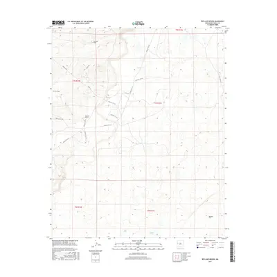
2017 Map of Red Lake Mission
USGS Topo · Published 2017About this map
The Red Lake Mission stands as a focal point in this 2017 survey of the Eastern Navajo Agency, situated at the intersection of a complex web of Bureau of Indian Affairs and Indian Service routes. The landscape is defined by its intermittent water features and broad drainage patterns, including the notable Atarque Draw in the north and Terrero Draw to the west. These seasonal waterways cut through the high desert terrain, eventually leading toward seasonal pools such as Bull Lake and Laguna Larga.
Find a feature on this map
22 named features on this map. Tap any name to fly to it.
Don’t see what you’re looking for? This feature index may not catch every label — zoom into the map to look around manually.
Map Details
Editions of this 2017 Red Lake Mission Map
This is the sole edition of this map. No revisions or reprints were ever made.
Other maps of this area

1954 · Saint Johns
USGS Topo · 1:250,000

1957 · Saint Johns
USGS Topo · 1:250,000

1958 · Saint Johns
USGS Topo · 1:250,000

1962 · Saint Johns
USGS Topo · 1:250,000

1967 · Red Lake Mission
USGS Topo · 1:24,000

1967 · Chimney Hill
USGS Topo · 1:24,000
1967 · Goat Hill
USGS Topo · 1:24,000

1967 · Cerro Alto
USGS Topo · 1:24,000
1967 · Cerro Pomo
USGS Topo · 1:24,000
1967 · Nicoll Lake
USGS Topo · 1:24,000