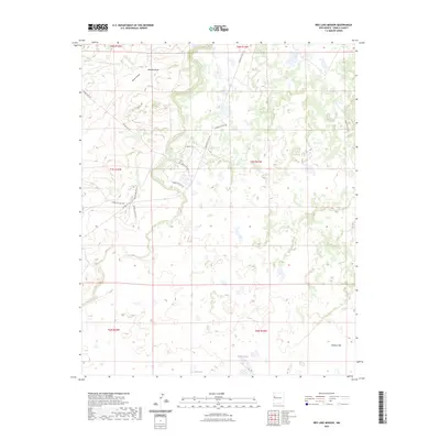
2023 Map of Red Lake Mission
USGS Topo · Published 2023About this map
Laguna Large and Bull Lake mark the lower elevations of this high-desert landscape in Cibola County, where seasonal drainages like Atarque Draw and Terrero Draw define the movement of water across the plateau. The area is characterized by a network of Bureau of Indian Affairs and Indian Service routes, reflecting the ongoing infrastructure management within this New Mexico region. Broad topographic features such as Peñasco Flat indicate the open, expansive nature of the terrain. The integration of modern roadways like Sierra Alto Rd and various Indian Service Routes demonstrates the evolution of local transit through this rural ranching and traditional land-use area. This 2023 edition provides a clear record of current land boundaries and water features as they exist in the early twenty-first century.
Find a feature on this map
22 named features on this map. Tap any name to fly to it.
Don’t see what you’re looking for? This feature index may not catch every label — zoom into the map to look around manually.
Map Details
Editions of this 2023 Red Lake Mission Map
This is the sole edition of this map. No revisions or reprints were ever made.
Other maps of this area

1954 · Saint Johns
USGS Topo · 1:250,000

1957 · Saint Johns
USGS Topo · 1:250,000

1958 · Saint Johns
USGS Topo · 1:250,000

1962 · Saint Johns
USGS Topo · 1:250,000

1967 · Red Lake Mission
USGS Topo · 1:24,000

1967 · Chimney Hill
USGS Topo · 1:24,000
1967 · Goat Hill
USGS Topo · 1:24,000

1967 · Cerro Alto
USGS Topo · 1:24,000
1967 · Cerro Pomo
USGS Topo · 1:24,000
1967 · Nicoll Lake
USGS Topo · 1:24,000