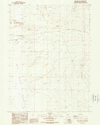
1988 Map of Red Lake NE
USGS Topo · Published 1989About this map
The Red Desert Basin dominates this late-twentieth-century landscape in Sweetwater County, Wyoming, revealing a high-desert environment defined by shifting Sand Dunes and sparse water sources. The map captures the industrial footprint of energy exploration, marked by scattered Gas Wells and several Drill Holes that dot the interior sections. Accessibility is limited to the Luman Ranch Road and various 4wd tracks, reflecting the isolation of this corner of the Red Desert. This survey shows the drainage patterns of Red Creek as it winds through the northern sections, while topographical details like the Horseshoe Bend highlight the intricate erosion of the Wyoming basin. For historians and researchers, these details illustrate the delicate balance between the natural arid landscape and the mid-century infrastructure required for resource extraction.
Find a feature on this map
9 named features on this map. Tap any name to fly to it.
Don’t see what you’re looking for? This feature index may not catch every label — zoom into the map to look around manually.
Map Details
Editions of this 1988 Red Lake NE Map
This is the sole edition of this map. No revisions or reprints were ever made.
Other maps of this area

1954 · Rock Springs
USGS Topo · 1:250,000

1955 · Lander
USGS Topo · 1:250,000

1958 · Lander
USGS Topo · 1:250,000

1958 · Rock Springs
USGS Topo · 1:250,000

1960 · Red Lake
USGS Topo · 1:62,500

1960 · Lost Creek Butte
USGS Topo · 1:62,500

1960 · Five Fingers Butte
USGS Topo · 1:62,500

1960 · Lost Creek Lake
USGS Topo · 1:62,500

1961 · Lander
USGS Topo · 1:250,000

1962 · Rock Springs
USGS Topo · 1:250,000