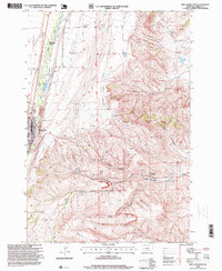
1996 Map of Red Lodge East
USGS Topo · Published 1999About this map
The coal-mining heritage of Carbon County is etched into the landscape between Red Lodge and Bearcreek. In this mid-1990s environment, the terrain is defined by the transition from the West Bench and East Bench plateaus into the deeply carved coulees of the eastern foothills. Industrial history is pervasive, with extensive mine dumps and specific sites like the Smith Mine, Brophy Mine, and Foster Mine marking the hillsides. These mines were central to the local economy and the development of surrounding worker settlements such as Washoe.
Find a feature on this map
46 named features on this map. Tap any name to fly to it.
Don’t see what you’re looking for? This feature index may not catch every label — zoom into the map to look around manually.
Map Details
Editions of this 1996 Red Lodge East Map
This is the sole edition of this map. No revisions or reprints were ever made.
Other maps of this area

1932 · Red Lodge No 2
USGS Topo · 1:48,000

1932 · Red Lodge No 1
USGS Topo · 1:48,000

1944 · Red Lodge
USGS Topo · 1:62,500

1954 · Billings
USGS Topo · 1:250,000

1956 · Roberts
USGS Topo · 1:24,000

1956 · Mount Maurice
USGS Topo · 1:62,500

1956 · Castagne
USGS Topo · 1:24,000

1956 · The Big Slide
USGS Topo · 1:24,000

1957 · Billings
USGS Topo · 1:250,000

1958 · Billings
USGS Topo · 1:250,000