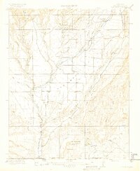
1913 Map of Red Mesa
USGS Topo · Published 1913About this map
La Plata River flows southward through this high-altitude landscape, defining a region where early irrigation efforts supported isolated settlements near the Colorado New Mexico Boundary Line. The map illustrates a transitional period of development, anchored by the Red Mesa landform and the vital waters of the Red Mesa Reservoir. Local social structures are evident in the placement of the Mormon Church and rural schoolhouses such as Rockville School and Bruner School, which served the farming families of Redmesa and Kline.
Find a feature on this map
41 named features on this map. Tap any name to fly to it.
Don’t see what you’re looking for? This feature index may not catch every label — zoom into the map to look around manually.
Map Details
Editions of this 1913 Red Mesa Map
4 editions found

Other maps of this area

1889 · Largo
USGS Topo · 1:250,000

1889 · Chaco
USGS Topo · 1:250,000

1892 · Chaco
USGS Topo · 1:250,000

1895 · Largo
USGS Topo · 1:250,000

1895 · La Plata
USGS Topo · 1:62,500

1897 · La Plata
USGS Topo · 1:62,500

1898 · Durango
USGS Topo · 1:62,500

1899 · La Plata
USGS Topo · 1:62,500

1907 · Durango
USGS Topo · 1:62,500

1908 · Ignacio
USGS Topo · 1:125,000