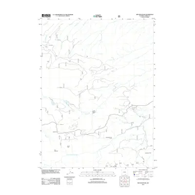
2012 Map of Red Mountain
USGS Topo · Published 2012About this map
Battle Pass serves as a central landmark in this high-elevation portion of the Sierra Madre range, where the continental divide marks the drainage between the Colorado and Mississippi River basins. The area is characterized by a network of forest roads, including FS RD 443 and FS RD 550, that provide access to historic mining and cattle-grazing terrain. Genealogical and local history interest is anchored at Battle Cem, a site that remains a quiet marker of the region's early pioneers and prospectors. The landscape is carved by deep drainages such as Slaughterhouse Gulch and Hidden Treasure Gulch, which feed into the N Fork Encampment River. In the southern half of the quadrangle, peaks like Red Mountain and Doane Peak overlook the alpine meadows of Deadhorse Park, reflecting the rugged character of Wyoming's southern mountains during the early twenty-first century.
Find a feature on this map
35 named features on this map. Tap any name to fly to it.
Don’t see what you’re looking for? This feature index may not catch every label — zoom into the map to look around manually.
Map Details
Editions of this 2012 Red Mountain Map
This is the sole edition of this map. No revisions or reprints were ever made.
Other maps of this area

1932 · Savery
USGS Topo · 1:96,000

1939 · Saratoga
USGS Topo · 1:125,000

1940 · Savery
USGS Topo · 1:125,000

1954 · Rawlins
USGS Topo · 1:250,000

1958 · Rawlins
USGS Topo · 1:250,000

1961 · Red Mountain
USGS Topo · 1:24,000

1961 · Bridger Peak
USGS Topo · 1:24,000

1961 · Encampment
USGS Topo · 1:24,000
1961 · Dudley Creek
USGS Topo · 1:24,000
1961 · Cow Creek Ranch
USGS Topo · 1:24,000