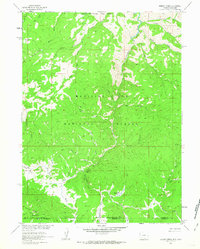
1961 Map of Dudley Creek
USGS Topo · Published 1963About this map
The Sierra Madre mountains dominate this 1961 survey, where the Continental Divide weaves across the high country along the border of the Medicine Bow National Forest and the Routt National Forest. This remote landscape, spanning the Wyoming and Colorado state line, is defined by an intricate network of drainage systems feeding the Main Fork Encampment River, including Dudley Creek, Soldier Creek, and Cascade Creek.
Find a feature on this map
38 named features on this map. Tap any name to fly to it.
Don’t see what you’re looking for? This feature index may not catch every label — zoom into the map to look around manually.
Map Details
Editions of this 1961 Dudley Creek Map
4 editions found
Other maps of this area

1911 · Hahns Peak
USGS Topo · 1:125,000

1913 · Hahns Peak
USGS Topo · 1:125,000

1939 · Saratoga
USGS Topo · 1:125,000

1954 · Rawlins
USGS Topo · 1:250,000

1954 · Craig
USGS Topo · 1:250,000

1955 · Davis Peak
USGS Topo · 1:24,000

1956 · Pearl
USGS Topo · 1:62,500

1957 · Craig
USGS Topo · 1:250,000

1958 · Rawlins
USGS Topo · 1:250,000

1958 · Craig
USGS Topo · 1:250,000