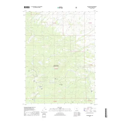
2017 Map of Red Mountain
USGS Topo · Published 2017About this map
Sierra Madre peaks dominate this high-altitude section of the Medicine Bow National Forest, where the Continental Divide National Scenic Trail winds through some of the state's most storied mountain terrain. The map centers on Battle Pass, a significant crossing point near the Battle Cem, providing a look at the landscape's historical mining and transit legacy. Drainages like Hidden Treasure Gulch and Slaughterhouse Gulch feed into the N Fork-Encampment River, illustrating the complex water network that once supported early prospecting and timber operations.
Find a feature on this map
38 named features on this map. Tap any name to fly to it.
Don’t see what you’re looking for? This feature index may not catch every label — zoom into the map to look around manually.
Map Details
Editions of this 2017 Red Mountain Map
This is the sole edition of this map. No revisions or reprints were ever made.
Other maps of this area

1932 · Savery
USGS Topo · 1:96,000

1939 · Saratoga
USGS Topo · 1:125,000

1940 · Savery
USGS Topo · 1:125,000

1954 · Rawlins
USGS Topo · 1:250,000

1958 · Rawlins
USGS Topo · 1:250,000

1961 · Red Mountain
USGS Topo · 1:24,000

1961 · Bridger Peak
USGS Topo · 1:24,000

1961 · Encampment
USGS Topo · 1:24,000
1961 · Dudley Creek
USGS Topo · 1:24,000
1961 · Cow Creek Ranch
USGS Topo · 1:24,000