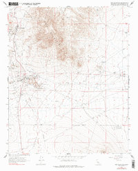
1967 Map of Red Mountain
USGS Topo · Published 1978About this map
Red Mountain and the neighboring settlement of Atolia anchor this high-desert mining landscape as it appeared in the late 1960s. The region is defined by a dense concentration of mineral extraction infrastructure, with numerous mines, trenches, and tailings ponds clustered along the southern slopes of the namesake Red Mountain peak. Historical industrial activity is further evidenced by the St Elmo Mine and the distinctive path of the Old Railroad Grade cutting across the terrain toward the south.
Find a feature on this map
30 named features on this map. Tap any name to fly to it.
Don’t see what you’re looking for? This feature index may not catch every label — zoom into the map to look around manually.
Map Details
Editions of this 1967 Red Mountain Map
3 editions found
Other maps of this area

1903 · Randsburg
USGS Topo · 1:62,500

1911 · Randsburg
USGS Topo · 1:62,500

1912 · Randsburg
USGS Topo · 1:62,500

1915 · Searles Lake
USGS Topo · 1:250,000

1947 · Trona
USGS Topo · 1:250,000

1948 · Trona
USGS Topo · 1:250,000

1953 · Trona
USGS Topo · 1:250,000
1954 · Boron
USGS Topo · 1:62,500

1954 · Cuddeback Lake
USGS Topo · 1:62,500

1956 · Fremont Peak
USGS Topo · 1:62,500