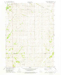
1978 Map of Red Oak South
USGS Topo · Published 1978About this map
Agricultural lands and rolling drainages dominate this landscape south of Red Oak, where the Nishnabotna R cuts through the northwest corner of the quadrangle. The map captures the infrastructure of late-1970s rural Iowa, showing the Burlington Northern line and a prominent Old Railroad Grade that traces the historical movement of goods across the prairie. Small communities and rural gathering points like Nyman and Hewitt are documented alongside local landmarks such as the Fremont Ch and Mt Hope Cem. The transition between Montgomery Co and Page Co is clearly marked, illustrating how township boundaries like Grant, Fremont, and Scott organized the farming economy. Waterways including West Tarkio Creek and the Tarkio River provide natural landmarks for researchers tracing 20th-century land use and family farm locations.
Find a feature on this map
26 named features on this map. Tap any name to fly to it.
Don’t see what you’re looking for? This feature index may not catch every label — zoom into the map to look around manually.
Map Details
Editions of this 1978 Red Oak South Map
This is the sole edition of this map. No revisions or reprints were ever made.
Other maps of this area

1954 · Omaha
USGS Topo · 1:250,000

1955 · Nebraska City
USGS Topo · 1:250,000

1957 · Nebraska City
USGS Topo · 1:250,000

1957 · Omaha
USGS Topo · 1:250,000

1958 · Omaha
USGS Topo · 1:250,000

1958 · Nebraska City
USGS Topo · 1:250,000

1978 · Stanton
USGS Topo · 1:24,000

1978 · Shenandoah East
USGS Topo · 1:24,000

1978 · Stanton SW
USGS Topo · 1:24,000

1978 · Wallin
USGS Topo · 1:24,000