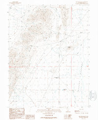
1989 Map of Red Rock Knoll
USGS Topo · Published 1989About this map
The Beaver River and its expansive Beaver Bottoms wetlands define the eastern corridor of this Utah landscape, serving as a vital water source in an arid interior basin. Management of this limited resource is evident in the presence of the Red Rock No 1 Reservoir and Red Rock No 2 Reservoir, which anchor the central rangeland. To the west, the terrain rises sharply into the Red Hills, where Black Rock Pass provides a natural transit point through the uplift. The distribution of 4WD tracks and scattered infrastructure like the Corral and Well reflect a landscape shaped by seasonal grazing and resource extraction. Between the hills and the river, Shorts Valley and the prominent Red Rock Knoll create a varied topography of washes and alluvial fans typical of the Great Basin's drainage patterns.
Find a feature on this map
15 named features on this map. Tap any name to fly to it.
Don’t see what you’re looking for? This feature index may not catch every label — zoom into the map to look around manually.
Map Details
Editions of this 1989 Red Rock Knoll Map
This is the sole edition of this map. No revisions or reprints were ever made.
Other maps of this area

1885 · Beaver
USGS Topo · 1:250,000

1953 · Richfield
USGS Topo · 1:250,000

1958 · Richfield
USGS Topo · 1:250,000

1960 · Beaver Lake Mts.
USGS Topo · 1:62,500

1972 · Headlight Mtn
USGS Topo · 1:24,000
1972 · Sevier Lake SW
USGS Topo · 1:24,000

1973 · Black Rock
USGS Topo · 1:24,000

1973 · Read
USGS Topo · 1:24,000
1973 · Cat Canyon
USGS Topo · 1:24,000

1980 · Wah Wah Mts. North
USGS Topo · 1:100,000