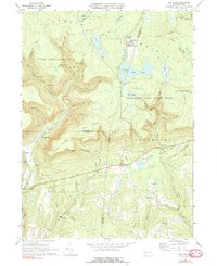
1969 Map of Red Rock
USGS Topo · Published 1977About this map
Benton Air Force Station stands as a prominent Cold War-era landmark atop North Mountain, marking a high-altitude presence in this corner of Pennsylvania. To the south, the landscape is defined by the steep escarpments and waterfalls of Ricketts Glen State Park, where Kitchen Creek and Ganoga Glen carve through the plateau. This 1969 survey captures the area's transition from a logging and industrial past—evidenced by the Old Railroad Grade and the Shale Pit—to a landscape dominated by conservation and recreation, centered on Lake Jean, Lake Rose, and Lake Leigh.
Find a feature on this map
69 named features on this map. Tap any name to fly to it.
Don’t see what you’re looking for? This feature index may not catch every label — zoom into the map to look around manually.
Map Details
Editions of this 1969 Red Rock Map
4 editions found
Other maps of this area

1891 · Harveys Lake
USGS Topo · 1:62,500

1893 · Harvey Lake
USGS Topo · 1:62,500

1894 · Shickshinny
USGS Topo · 1:62,500

1894 · Bloomsburg
USGS Topo · 1:62,500

1934 · Laporte
USGS Topo · 1:62,500

1946 · Shickshinny
USGS Topo · 1:31,680

1946 · Dutch Mtn
USGS Topo · 1:24,000

1946 · Sweet Valley
USGS Topo · 1:24,000

1947 · Stillwater
USGS Topo · 1:24,000

1947 · Benton
USGS Topo · 1:31,680
Featured Places
- Colley Township, PA
- Davidson Township, PA
- Red Rock, Fairmount Township
- Mossville, Fairmount Township
- Sugarloaf Township, PA